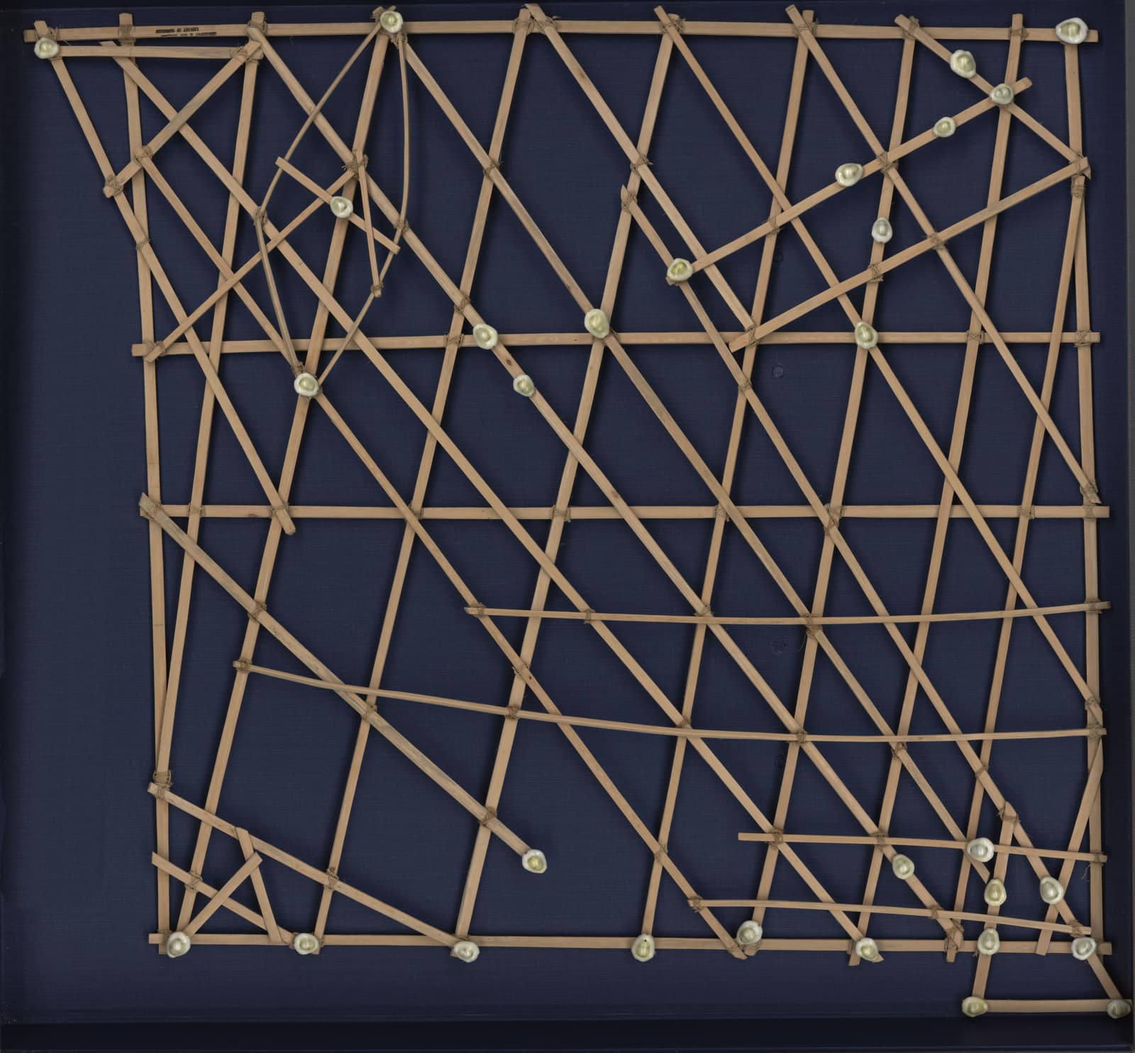
A map of the swell: Marshall Islands stick charts
- Dated
- Place
- Majuro, Marshall Islands · Marshallese navigators
- Coordinates
- 7° 05′ N · 171° 23′ E (approximate)
- Remains
- Intact
Library of Congress, Geography and Map DivisionPDMOriginal record
Data saver is on. Images load only when you ask. You can change this in Settings at any time.
From the archivist
This civilization lived on atolls so low that a coconut palm showed above the horizon only some twenty kilometres out to sea. Its navigators did not look for land; they felt for it. A swell rolling in from the east bent around an island, struck its reef and sent back a fainter wave, and a canoe crossing these meetings of water rocked in a way the body learned to recognise.
What is kept here is how that recognition was taught. Thin sticks lashed with fibre: the straight ones for currents and regular waves, the curved ones for the great ocean swells, and small shells tied on for the atolls. It was never taken to sea. A learner studied it ashore, committed it to memory, then left it behind. The chart travelled inside the navigator.
This one is large and nearly square, a rebbelib, laid out for the whole archipelago, the Ratak chain in the east and the Ralik chain in the west. Its knowledge was held within families and passed on with care. Under German, Japanese and then American rule, long voyages grew rare. In the early years of this century one of the last navigators, Captain Korent Joel, asked that the waves be learned again before those who knew them were gone, and young sailors in Majuro began to listen.
Established
- Marshallese navigators modelled ocean swells and their bending around islands in lattices of coconut midribs or pandanus roots, with shells for islands (Genz et al. 2009).
- These lattices were teaching devices studied ashore, not charts carried at sea (Genz et al. 2009).
- Older literature distinguishes three kinds: the mattang, an abstract training model; the meddo, part of an island chain; the rebbelib, one or both chains (Library of Congress labels).
- The chart shown is a rebbelib of wood and shells, 67 by 72 cm, covering the Ratak and Ralik chains, catalogued as made in the 1920s, probably in Majuro (Library of Congress).
- The archipelago's atolls are so low that the tops of their coconut palms can be seen only about 20 km offshore (Genz et al. 2009).
- From 2005, Captain Korent Joel, the canoe school Waan Aelõñ in Majel (founded by Alson Kelen in 1989) and the University of Hawaiʻi worked to relearn wave navigation (Genz et al. 2009; Smithsonian 2016).
Interpretation
How each chart should be read is debated: navigators kept their knowledge within families and shared it sparingly, so the names, spellings and meanings recorded by nineteenth and early twentieth century observers may not match what individual navigators intended. Some wave patterns described by navigators still have no clear oceanographic explanation.
In 10,000 years
In 10,000 years, the sticks will be dust; will anyone still feel an island through the hull of a canoe?
Sources (5)
- Genz, J., Aucan, J., Merrifield, M., Finney, B., Joel, K., Kelen, A. Wave navigation in the Marshall Islands: comparing indigenous and Western scientific knowledge of the ocean. Oceanography 22 (2), 2009, p. 234-245. · tos.org
- Genz, J. Resolving ambivalence in Marshallese navigation: relearning, reinterpreting, and reviving the stick chart wave models. Structure and Dynamics 9 (1), 2016, p. 8-40. · escholarship.org
- Library of Congress, Geography and Map Division. [Marshall Islands stick chart, Rebbelib type], [Majuro, 192-?], 1 model, wood and shells, 67 x 72 cm, G9461.P5 1920 .M24. · www.loc.gov
- Library of Congress, Geography and Map Division. [Marshall Islands stick chart, Mattang type] and [Marshall Islands stick chart, Meddo type], [Majuro, 192-?], label texts. · www.loc.gov
- Langlois, K. Science and tradition are resurrecting the lost art of wave piloting. Smithsonian Magazine, 2 February 2016. · www.smithsonianmag.com