The Iya of Benin: the earth walls of a kingdom, disappearing
- Dated
- Place
- Benin City and Edo State, Nigeria · The Edo of the kingdom of Benin and their Esan neighbours, southern Nigeria
- Coordinates
- 6° 20′ N · 5° 38′ E (approximate)
- Remains
- Fragmentary
This fragment shows an object held as sacred.
It is shown here as the institution that holds it presents it. Some communities connected to it ask that it be viewed with care. You may choose to see the image, or read the record without it.
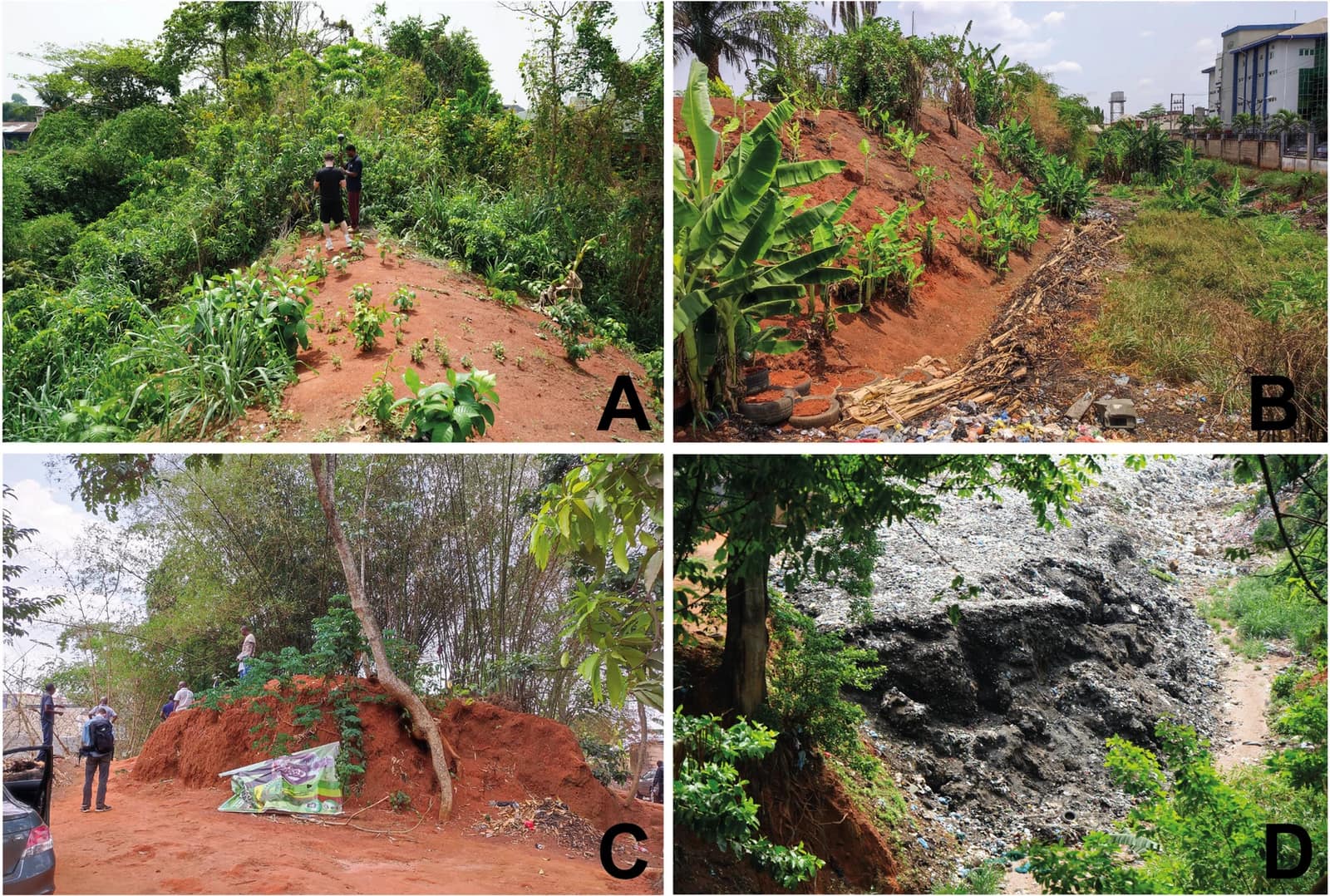
Image veiled by default
Schepers, C. et al. (2025), Current Condition of the Iya in Benin City, African Archaeological Review 42, fig. 5, CC BY 4.0, via Wikimedia CommonsCC-BY-4.0Original record
Data saver is on. Images load only when you ask. You can change this in Settings at any time.
From the archivist
Around the city of Benin, and far out into the forest beyond it, people dug. They dug a ditch and threw the red earth up beside it into a bank, and when a village needed a boundary they dug another, and then another, for centuries. No single person planned it. Each line said: here is our land, here is where we live.
In the 1970s the archaeologist Patrick Darling walked some fifteen hundred kilometres of these banks and estimated that the whole network might reach sixteen thousand. Around the capital the moat was deepest. Tradition says that when a king deepened it, charm pots were buried at the gates, and the gates became places where the world of the living met the world of the dead.
Then the city grew over them. Earth was dug out for bricks and road repairs. Roads cut through the banks; houses were built on them; the ditches filled with rubbish. Of the inner ring, about half is gone.
In one place, inside a sacred grove beside a shrine to the kings of Benin, the bank still stands under the trees, almost untouched. What protected it was not a law. It was that people still held the place to be holy.
Established
- The Iya (Iyala in the Esan area) are a network of ditches and earth banks that once enclosed and linked more than five hundred settlements in the Benin and Esan territories (Schepers et al. 2025).
- Patrick Darling surveyed about 1,500 km of them on the ground between 1973 and 1977, and estimated that all the earthworks together reach some 16,000 km and cover about 6,500 km² (Schepers et al. 2025, citing Darling 1984).
- Guinness World Records lists them as the longest earthworks of the pre-mechanical era, citing Darling's 1977 estimate of about 150 million m³ of earth moved (Guinness World Records).
- Darling's project first dated the earthworks to the 13th to 15th centuries CE; later dates pushed the earliest back to the early 8th century CE at Ekhor n'Iro, east of Benin City (African Legacy, Bournemouth University).
- Colonial writers recorded traditions that attribute the city's inner Iya to Oba Oguola, or to other kings such as Ewuare or Esigie. Tradition also holds that when Oba Ewuare deepened the moat, charm pots were buried at the gates, which became ada, crossings between the world of the living and the world of the dead (Schepers et al. 2025).
- European visitors from the early 16th century onward described a city ringed by deep ditches, in one account more than 6 m wide and as deep (Schepers et al. 2025, citing Roth 1903).
- Of the 12.4 km of the Inner City Iya surveyed in 2025, only about 6 km of bank survive, and about 1 km of that is severely damaged; refuse dumping, sand and clay digging, roads and buildings are the main threats. On one well-preserved stretch, the drop from the top of the bank to the bottom of the ditch is 9 to 10 m (Schepers et al. 2025).
- A stretch of the inner Iya inside a sacred grove, with a shrine dedicated to the Obas of Benin, is in good condition and almost free of litter (Schepers et al. 2025).
- The Benin Iya, with Sungbo's Eredo, were placed on Nigeria's tentative list for World Heritage in 1995; a full nomination is still pending (Schepers et al. 2025).
Interpretation
The figure of 16,000 km is an extrapolation from about 1,500 km surveyed, and it adds up hundreds of separate boundaries dug by many communities over several centuries; it does not describe a single wall. Popular comparisons with the Great Wall of China or the Great Pyramid repeat this total without a peer-reviewed basis. Dates vary between sources (from the 8th to the 15th century for the earliest works) and much of the network has never been dated. Why the Iya were dug is debated: defence, the marking of farmland and community boundaries, protection from elephants, or spiritual barriers; they probably served several purposes at once. Popular accounts often say that the walls were destroyed by the British expedition of 1897, which sacked and burned Benin City (see RH-0021); the surveys consulted here instead attribute most of the loss to the growth of the city in the twentieth century.
Looking ahead
What we dig to say 'this is ours' outlasts the reasons we dug it. A thousand years from now, who will know what our boundaries meant?
Sources (4)
- Schepers, C., Hubert, J., Edward-Ekpu, U., Folorunso, C. A., Fonseca, S., LeQuesne, C., Omogbai, O., Linstädter, J. Current Condition of the Iya in Benin City, the Gates and Future Preservation Strategies. African Archaeological Review 42, 2025, p. 519-537. · doi.org
- Darling, P. J. Archaeology and History in Southern Nigeria: The Ancient Linear Earthworks of Benin and Ishan. Oxford, BAR International Series 215, 1984 (not consulted directly; cited through Schepers et al. 2025).
- Bournemouth University, School of Conservation Sciences. African Legacy: Benin Iya earthworks (project pages of P. J. Darling). · csweb.bmth.ac.uk
- Guinness World Records. Longest earthworks of the pre-mechanical era. · www.guinnessworldrecords.com
Related fragments
1500 to 1897
The Benin Bronzes
Benin City, Edo State, Nigeria · Africa
1300 to 1500
The heads of Ifẹ
Ile-Ife, Osun State, Nigeria · Africa
1100 to 1500
Great Zimbabwe
Near Masvingo, Zimbabwe · Africa