A place for everyone on Earth: the Global Positioning System
Before GPS, finding one's position meant stars, landmarks, charts and radio beacons and took skill; after it was opened fully to civilians in 2000, a small receiver anywhere on Earth could give its place within metres, at no charge, and navigation, timekeeping and mapping came to depend on satellites.
- Dated
- Place
- Vandenberg Space Force Base, California, United States · The United States Air Force and Department of Defense, with the engineers of Rockwell International, which built the first satellites; later civil agencies and users worldwide
- Coordinates
- 34° 45′ N · 120° 34′ W (approximate)
- Remains
- Intact
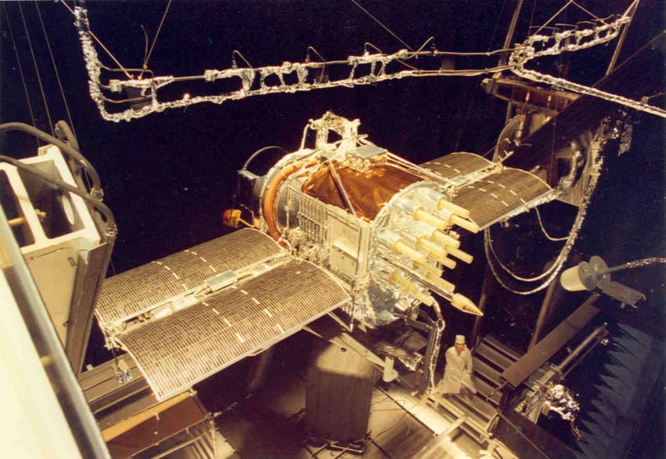

US Air Force (Arnold Engineering Development Complex), public domain, via Wikimedia CommonsPDMOriginal record
Data saver is on. Images load only when you ask. You can change this in Settings at any time.
From the archivist
For most of their history, the people of this civilization found their way by the sun and the stars, by the shape of coasts and the set of the swell, and later by compasses, charts and radio beacons. It took knowledge, and it could fail.
On 22 February 1978 a rocket rose from the California coast with a satellite that carried atomic clocks. Others followed. Each one sent out, again and again, the time on its clock and where it was. A receiver on the ground that heard four of them could work out, from the tiny delays, where it stood.
It was built for soldiers. In September 1983, after a lost airliner was shot down with everyone on board, the American president promised that civilians would be allowed to use it. For years the signal they received was blurred on purpose. At midnight on 1 May 2000 the blurring was switched off.
The satellite kept here, photographed in a test chamber in 1977, belongs to the first generation. Its descendants now tell ships, aircraft, farmers and people lost in a strange city where they are, and keep time for the networks of an entire planet.
Established
- On 22 February 1978 an Atlas F rocket launched from Vandenberg Air Force Base, California, placed Navstar 1, the first satellite of the Global Positioning System, in orbit (Air Force Historical Foundation).
- Between 1978 and 1985 eleven Block I development satellites built by Rockwell International were launched on Atlas F rockets, one of them lost in a launch failure (Pace et al. 1995).
- On 16 September 1983, after the Soviet Union shot down Korean Air Lines flight 007, which had strayed into its airspace, President Reagan offered to make GPS available to civilian aircraft free of charge once the system became operational (Pace et al. 1995).
- In 1995 the US Air Force Space Command declared that GPS had reached full operational capability, with a constellation of 24 operational Block II and IIA satellites (Pace et al. 1995).
- Until 2000 the signal open to the public was deliberately degraded by a feature called Selective Availability; it was switched off a few minutes after midnight Eastern time at the end of 1 May 2000, on the order of President Clinton, making civilian receivers about ten times more accurate (GPS.gov; White House 2000).
- Other global systems followed: Europe's Galileo began its Initial Services on 15 December 2016, and China's BeiDou-3 was commissioned for global service on 31 July 2020 (EUSPA 2016; China Satellite Navigation Office 2020).
Interpretation
The story that GPS was opened to the world because of the destruction of flight 007, with its 269 people, is a simplification: the 1983 announcement was a promise about a system not yet built, the airliner had strayed through a navigation error of a kind satellites might one day prevent, and the full precision reached civilians only in 2000. The date of full operational capability also varies between accounts: Air Force Space Command's declaration was reported in the spring of 1995, while the Air Force itself later marked 17 July 1995 as the anniversary. GPS is still a military system that civilian life has come to lean on for navigation, for the timing of telephone and power networks and for finance; how exposed that makes societies to jamming, spoofing or failure is widely debated, and is one reason why Russia's GLONASS, Galileo and BeiDou exist beside it.
In 10,000 years
In 10,000 years, will the last of these satellites still be circling in their high orbits, silent clocks that once told a whole species where it stood?
Sources (7)
- Pace, S., Frost, G., Lachow, I., Frelinger, D., Fossum, D., Wassem, D. K., Pinto, M. The Global Positioning System: Assessing National Policies. RAND Corporation, MR-614-OSTP, 1995, Appendix B: GPS history, chronology, and budgets. · www.rand.org
- Air Force Historical Foundation. February 22, 1978 (On this day in history). · afhistory.org
- Encyclopaedia Britannica. Korean Air Lines flight 007. · www.britannica.com
- The White House, Office of the Press Secretary. Statement by the President regarding the United States' decision to stop degrading Global Positioning System accuracy, and fact sheet, 1 May 2000. · clintonwhitehouse4.archives.gov
- GPS.gov (National Coordination Office for Space-Based Positioning, Navigation, and Timing). Selective Availability. · www.gps.gov
- EU Agency for the Space Programme. Galileo begins delivery of Initial Services, 15 December 2016. · www.euspa.europa.eu
- China Satellite Navigation Office. Completion and commissioning of the BeiDou-3 Navigation Satellite System, 31 July 2020. · en.beidou.gov.cn
Related fragments
1957
Sputnik 1, the first artificial satellite
Baikonur Cosmodrome, Kazakhstan · Asia
1300 to 1386 CE
The hours struck by iron: the mechanical clock of Salisbury
Salisbury Cathedral, Salisbury, Wiltshire, United Kingdom · Europe
1976
Hōkūleʻa
Hawaiʻi, United States, to Tahiti, French Polynesia · Oceania
1920 to 1929
A map of the swell: Marshall Islands stick charts
Majuro, Marshall Islands · Oceania